IN PROGRESS: Jefferson Greenway
Overview

The Virginia State Capitol Building was designed and sited deliberately by Thomas Jefferson to overlook the James River. Generous lawns and views of the city below remain intact today, but over time the site’s connection to the James has been obscured by development in Richmond’s Downtown and Shockoe Districts.
The proposed greenway is inspired by Thomas Jefferson’s original vision of a hilltop capitol, broadly facing the fall line of the James River. With that vision as its source, the greenway will provide a strong natural thread that will visually, symbolically, and physically reconnect Richmond’s Capitol Square with the James.
In 2013, Capital Trees partnered with The Alliance for Chesapeake Bay (ACB) to restore this connection through thoughtful interventions along the 10th Street Corridor and continuation work was completed under ACB’s 2010 “Greening the Capitol Initiative,” which raised Richmond’s profile as the “greenest capitol in the nation” according to the Environmental Protection Agency.
10th Street extends in a north-south direction from the Capitol to the Kanawha Canal, crossing Bank, Main, Cary, Byrd and Canal Streets, and serving a variety of sites such as the Federal Courts Building, SunTrust Bank and multiple financial institutions, the James Center, RMA plaza and parking facilities, retail establishments, legal offices and residential apartment units.
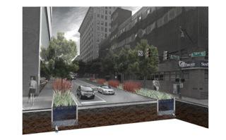
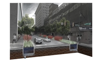
The character, condition and use of the 10th Street streetscape varies greatly among blocks, further obscuring the connection between Jefferson’s Capitol and the James River. In an effort to reveal this connection, promote pedestrian activity and develop historical and environmental narratives of its significance, Capital Trees and ACB have worked with 3north and Waterstreet Studio to develop a master plan for the 10th Street Corridor, branding the site “The Jefferson Greenway.”
The Jefferson Greenway Master Plan calls for pavement and crosswalk improvements, pedestrian-scaled lighting and street furnishings, street tree plantings along curb lines and within medians, and storm water retrofits to reduce runoff and improve water quality. Elevated and in-ground signage is recommended as a means of delivering education messages, and new environmental technologies are employed to improve the condition and environmental health of the site.

Location:
Comments
Connections
- United States
- VeniceUnited States
- SarasotaUnited States
- NokomisUnited States
- United States
- United States
- United States
- Villanueva y GeltrúSpain
- United States
- United States
- SarasotaUnited States
- VeniceUnited States
- BrooklynUnited States
- BenidormSpain
- United States
- EnglewoodUnited States
- United States
- SarasotaUnited States
- United States
- FlorianópolisBrazil
- SarasotaUnited States
- PereiraColombia
- United States
- VeniceUnited States
- FlorianópolisBrazil
Multimedia
IN PROGRESS: Jefferson Greenway

Impacts
No impacts have been left for this site yet - be the first!


