Bushwick Inlet Park
![Waterfront/Riverside Park: Place where you can relax, walk or ride along and play by the water (includes water bodies of all types). May include a beach; swimming and wading may be possible. Waterfront/Riverside Park](https://www.opengreenmap.org/sites/default/files/taxonomy_image/category_pictures_62.gif)
![Park/Recreation Area: Green space that offers a place to relax and play outdoors. May include sports fields, picnicking, running paths, canoe rental, or workout/play equipment, along with diverse vegetation and a pond, creek or other water feature. Park/Recreation Area](https://www.opengreenmap.org/sites/default/files/taxonomy_image/category_pictures_94.gif)
![Solar Energy Site: Place where you can see solar panels, passive solar examples and/or get information about renewable energy. Includes buildings, organizations, training programs, solar energy shops and contractors, government and utility company sites. Solar Energy Site](https://www.opengreenmap.org/sites/default/files/taxonomy_image/category_pictures_17.gif)
![Water Recycling: Uses plants, aquatic animals, layered soils, movement, (constructed) wetlands and or/ swales to aerate, filter and purify water, without adding chemicals. Systems that slow the drainage in the built environment, grey water, rainwater gardens, rain barrels and other types of high and low technology water recycling systems that reduce consumption can be included. Water Recycling](https://www.opengreenmap.org/sites/default/files/taxonomy_image/category_pictures_20.gif)
![Green Roof: A planted roof that cools and cleans the air and retains rainwater while providing beauty, wildlife habitat, fire and soundproofing. Also referred to as eco-roofs, vegetated roofs, living roofs, planted roof, biotope or cool roof. Green Roof](https://66.39.69.165/sites/default/files/taxonomy_image/category_pictures_23.gif)
![Energy Conservation: Site, service, project or products that minimize the use of energy. Energy Conservation](https://www.opengreenmap.org/sites/default/files/taxonomy_image/category_pictures_29.gif)
![Senior Friendly Site: An area where people who may have walking difficulties can enjoy nature and green living. May include areas where one can chat or relax, related organizations and resources, including senior centers and eco-meeting points. Senior Friendly Site](https://www.opengreenmap.org/sites/default/files/taxonomy_image/senior_friendly.gif)
Overview
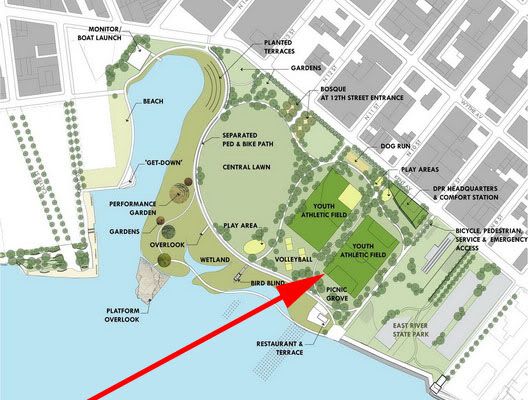
In 2005, New York City’s rezoning of Williamsburg and Greenpoint mapped 28 acres of future waterfront parkland for a community that has severely lacked parks and open space. The proposed future park would extend from N. 9th Street across the Bushwick Inlet to Quay Street, giving residents of Williamsburg and Greenpoint full access to the East River. The park vision includes a boat launch, a museum dedicated to the Civil War era battleship USS Monitor, picnic grounds, athletic fields, volleyball courts, wetland preserves, gardens, performance spaces, a dog run and a two mile bicycle and pedestrian path along the East River. The first phase of this development, a soccer field, began in March 2009 and was completed in January 2010. Construction on the second phase of this development will begin in Summer 2010.
Location:
Comments
Connections
- Brooklyn
- Thailand
- Longboat KeyUnited States
- Cluj-NapocaRumänien
- Amherst JunctionUnited States
- SarasotaUnited States
- SalvoUnited States
- Cluj-NapocaRumänien
- VeniceUnited States
- Johns IslandUnited States
- OspreyUnited States
- United States
- ArenthonFrankrike
- North PortUnited States
- Long Island CityUnited States
- Curitiba / PRBrasilien
- CaliColombia
- VeniceUnited States
- United Kingdom
- BrooklynUnited States
- Portugal
- SarasotaUnited States
- CaliColombia
- Port ElginKanada
- Kina
- United States
Impacts
No impacts have been left for this site yet - be the first!