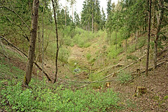
Veisteru Velna pēda / Veisteri Devil's Footprint
Übersicht
Ap 8 - 10 metrus dziļa un ap 30 metrus gara glaciokarsta ieplaka. Veidojusies ledus laikmeta beigu periodā, ilgstoši šeit saglabājoties milzu ledus bluķim.
Ziemeļos no Alūksnes - Mariņkalna ceļa, ap 10 metrus no ceļa, dienvidaustrumos no Ziediem, netālu no Karitāniem.
Aproximately 8 - 10 metres deep and 30 metres long glaciocarst deppression. Formed at the end of glacial period - here for longer time, hidden under a layer of mud there was an enormous chunk of ice.
North from Aluksne - Marinkalns road, some 10 metres from the road, south-east from Ziedi, near Karitani.
Location:
Javascript is required to view this map.
Kommentare
Verbindungen
Compare related sites, explore the related maps, find out about volunteering, how to get here and more. Soon, you will find ways to share this map here, too.
Every site using the same primary Icon on Open Green Map is automatically linked here. You can compare different approaches and solutions on this map and others around the world.
Choose a connections category from the list on the left.
Andere Orte auf der Karte
Ähnliche Orte weltweit
- Brazil
- DavosSwitzerland
- Switzerland
-
-
-
-
-
-
-
- Switzerland
- United States
- United States
-
-
- EurekaUnited States
-
-
-
- United States
-
-
-
-
- IthacaUnited States
Auswirkungen
No impacts have been left for this site yet - be the first!


 Hinzugefügt von


