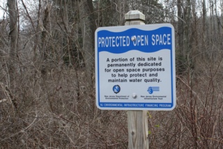
Bunnvale Protected Open Space
Overview


Open Space

Location:
Javascript is required to view this map.
Comments
Connections
Compare related sites, explore the related maps, find out about volunteering, how to get here and more. Soon, you will find ways to share this map here, too.
Every site using the same primary Icon on Open Green Map is automatically linked here. You can compare different approaches and solutions on this map and others around the world.
Choose a connections category from the list on the left.
Other Sites on Map
Related Sites Worldwide
- Hong Kong S.A.R., China
- Hong Kong S.A.R., China
- Canadá
- Taiwan
- Canadá
- Reino Unido
- Hong Kong S.A.R., China
- CaliColombia
- South Korea
- DrydenEstados Unidos
-
-
- Estados Unidos
- Reino Unido
- Estados Unidos
- IthacaEstados Unidos
- Hong Kong S.A.R., China
- Reino Unido
- Reino Unido
- IthacaEstados Unidos
- RadyrReino Unido
- Saint LouisEstados Unidos
- Estados Unidos
- San FranciscoEstados Unidos
- Estados Unidos
Multimedia

Bunnvale Protected Open Space

Impacts
No impacts have been left for this site yet - be the first!


