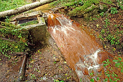
Rutkaviņu avoti / Rutkavinas springs
Descripción
Spēcīgu avotu grupa, ūdens satur daudz dzelzs un kaļķa. Avoti izveidojuši ap 20 metrus dziļu, ainavisku gravu.
Gaujas kreisajā krastā, 800 metrus lejpus Sējātu mājām, 5 kilometrus ziemeļos no Rankas.
Group of powerful springs, water contains iron and lime. Springs have formed approximately 20 metres deep, picturesque ravine.
Left bank of Gauja, 800 metres below Sejati farmstead, 5 kilometres north from Ranka.
Location:
Javascript is required to view this map.
Comentarios
Conexiones
Compare related sites, explore the related maps, find out about volunteering, how to get here and more. Soon, you will find ways to share this map here, too.
Every site using the same primary Icon on Open Green Map is automatically linked here. You can compare different approaches and solutions on this map and others around the world.
Choose a connections category from the list on the left.
Other Sites on Map
Related Sites Worldwide
- Cluj-NapocaRomania
- Al AinUnited Arab Emirates
- Canadá
- Canadá
- New YorkEstados Unidos
- Brazil
- ShokanEstados Unidos
- FlorianopolisBrazil
- Canadá
- RochesterEstados Unidos
-
- Santana de ParnaíbaBrazil
- RichmondEstados Unidos
- Petit-LancySwitzerland
- Switzerland
- Lebanon
- Estados Unidos
-
- Estados Unidos
- Estados Unidos
- Estados Unidos
- Lebanon
- Canadá
- Cluj-Napoca
-
Impactos
No impacts have been left for this site yet - be the first!


 added by


