Yarmouth County
NS
Interface
Descripción

This is an exciting geological site. Three major earth formations come together and all can be seen because of the coastal erosion taking place. It is an earthcache site (GC1691C) with much more detail at www.geocaching.com.

Location:
Javascript is required to view this map.
Comentarios
Conexiones
Compare related sites, explore the related maps, find out about volunteering, how to get here and more. Soon, you will find ways to share this map here, too.
Every site using the same primary Icon on Open Green Map is automatically linked here. You can compare different approaches and solutions on this map and others around the world.
Choose a connections category from the list on the left.
Other Sites on Map
- Yarmouth County
- Yarmouth County
- Yarmouth County
Related Sites Worldwide
-
-
-
- Estados Unidos
- Saint Lucia
-
-
-
- Portugal
- Estados Unidos
-
- Taiwan
-
-
-
-
-
- Saint Lucia
-
- Lebanon
-
-
- IthacaEstados Unidos
- OaklandEstados Unidos
-
Multimedia

 added by
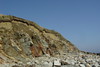
Impactos
No impacts have been left for this site yet - be the first!


