Florianópolis
SC
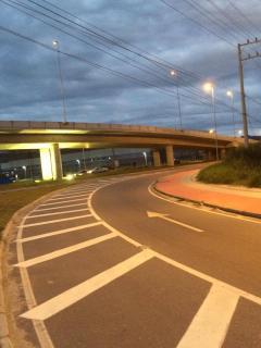
Ciclovia SC-401
Visão geral


Faixa exclusiva para circulação de bicicleta na rodovia de maior tráfego do norte da ilha. Proporciona segurança aos usuários que existem em grande número na cidade e estimula pessoas a escolherem um meio de transporte mais sustentável e agradável ao meio ambiente.

Location:
Javascript is required to view this map.
Comentários
Connections
Compare related sites, explore the related maps, find out about volunteering, how to get here and more. Soon, you will find ways to share this map here, too.
Every site using the same primary Icon on Open Green Map is automatically linked here. You can compare different approaches and solutions on this map and others around the world.
Choose a connections category from the list on the left.
Other Sites on Map
- Florianópololis
- Florianópolis
-
-
-
-
- Florianópolis
-
- Florianópolis
-
Related Sites Worldwide
- 美国
- 美国
- Charleston美国
- London
- 美国
- Petit-Lancy瑞士
- 美国
- 巴西
-
- Yogyakarta印度尼西亚
- 美国
- 瑞士
- 巴西
- Gainesville美国
- 美国
- 台湾
-
- Atlantic Highlands美国
- 黎巴嫩
- Akron美国
- Hillsborough美国
- 葡萄牙
- Buckeye Lake美国
- 美国
- 台湾
Multimedia
Ciclovia SC-401


Impacts
No impacts have been left for this site yet - be the first!


