Todo el Barrio
Pereira
Limites del Barrio Hamburgo
Descripción
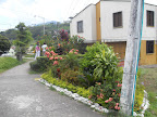

El barrio Hamburgo está ubicado al sur del municipio de Pereira, Colombia, en la comuna El Poblado, localizada en el subtramo No. 1 de la cuenca del río Consota. Los límites respecto al barrio son: al noroccidente con el barrio El Poblado I, al oriente con El Parque El Vergel y el barrio El Rocío Bajo y al sur con el barrio Rocío medio y Barajas y al sur oriente con El Rocío Alto .

Location:
Javascript is required to view this map.
Comentarios
Conexiones
Compare related sites, explore the related maps, find out about volunteering, how to get here and more. Soon, you will find ways to share this map here, too.
Every site using the same primary Icon on Open Green Map is automatically linked here. You can compare different approaches and solutions on this map and others around the world.
Choose a connections category from the list on the left.
Other Sites on Map
n/d
Related Sites Worldwide
- San FranciscoEstados Unidos
- Long Island CityEstados Unidos
- New York CityEstados Unidos
- Estados Unidos
-
- New YorkEstados Unidos
- BronxEstados Unidos
-
- Estados Unidos
- DetroitEstados Unidos
- New YorkEstados Unidos
- New YorkEstados Unidos
- Estados Unidos
- Hong Kong S.A.R., China
- BrooklynEstados Unidos
- Long Island CityEstados Unidos
- CoronaEstados Unidos
- Clinton
- Canadá
- Jackson HeightsEstados Unidos
-
- BaltimoreEstados Unidos
- BrooklynEstados Unidos
- BeyerbergGermany
- DinkelsbühlGermany
Multimedia

 added by
 Impactos
No impacts have been left for this site yet - be the first!


