Natural Bridge
Overview


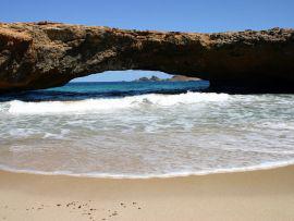
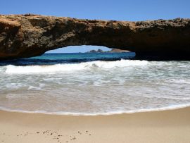
"Located in the eastern side of the island, it is limestone formation that was pounded for thousands of years by waves and wind creating a bridge that span for over 100 feet and it was over 25 feet high, making a impressive site on the island". (http://www.welcomearuba.com/natural-bridge.html)

Location:
Javascript is required to view this map.
Comments
Connections
Compare related sites, explore the related maps, find out about volunteering, how to get here and more. Soon, you will find ways to share this map here, too.
Every site using the same primary Icon on Open Green Map is automatically linked here. You can compare different approaches and solutions on this map and others around the world.
Choose a connections category from the list on the left.
Other Sites on Map
Related Sites Worldwide
- United States
-
-
-
-
- ChattanoogaUnited States
-
- Portugal
-
-
-
- Mali VilleGuinea
-
- MontclairUnited States
-
- Italy
-
- United States
-
-
-
- RebersburgUnited States
-
-
-
Multimedia
Natural Bridge

Impacts
No impacts have been left for this site yet - be the first!


