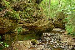
Vīdales kanjons / Vidale canyon
Overview
Ainavisku atsegumu virkne abos upes ielejas krastos vairāku simtu metru garā posmā, ūdenskritums sāngravā.
Lorumupes ielejā Slīteres Zilo kalnu nogāzē Vīdalē, austrumos no Vīdales - Mazirbes ceļa.
Group of picturesque outcrops along the both banks of river valley, small watefall in side ravine.
Lorumupe valley at the descent of Slitere Blue mountains, east from Vidale - Mazirbe road.
Location:
Javascript is required to view this map.
Comments
Connections
Compare related sites, explore the related maps, find out about volunteering, how to get here and more. Soon, you will find ways to share this map here, too.
Every site using the same primary Icon on Open Green Map is automatically linked here. You can compare different approaches and solutions on this map and others around the world.
Choose a connections category from the list on the left.
Other Sites on Map
Related Sites Worldwide
-
- MontclairUnited States
-
-
-
- Yarmouth CountyCanada
- Switzerland
- NatalBrazil
-
- IthacaUnited States
-
-
- United States
- United States
-
-
- United Kingdom
- Singapore
-
- United Kingdom
- IthacaUnited States
-
-
-
-
Impacts
No impacts have been left for this site yet - be the first!


 added by


