Cedar Ridge Preserve and Trail
![Eco-Tour/Nature Walk: Marks the beginning of a hiking trail, guided tour starting point or an interesting walk. Maps, signage and information may be found here. Eco-Tour/Nature Walk](https://www.opengreenmap.org/sites/default/files/taxonomy_image/category_pictures_97.gif)
![Significant Habitat: Notable wildlife ecosystem or natural breeding area that may be rare or especially beautiful and rich. Significant Habitat](https://www.opengreenmap.org/sites/default/files/taxonomy_image/category_pictures_82.gif)
![Wildlife Habitat: Native environment for animals and the plants that sustain them. Can represent native natural environments, or protected areas such as park reserves where larger animals and other wildlife can be found. Wildlife Habitat](https://www.opengreenmap.org/sites/default/files/taxonomy_image/category_pictures_83.gif)
![Amphibian Habitat: Area that is a good viewing site for frogs, newts and other amphibious species, which are indicators of a pond or wetland's health status. May include any kind of terrestrial ecosystem with amphibians. Amphibian Habitat](https://www.opengreenmap.org/sites/default/files/taxonomy_image/category_pictures_84.gif)
![Native Forests/Plants: Flora that is indigenous in the region, sometimes called old growth, heirloom or indigenous species. Native species requires less water and care than exotic imports, and usually attract more birds, bees and butterflies, and help the cycle of life stay in balance. May include a master gardener, permaculturalist or horticulturalist or information center. Native Forests/Plants](https://www.opengreenmap.org/sites/default/files/taxonomy_image/category_pictures_75.gif)
![Natural Corridor/Greenway: Often follows along a river or streambed, ravine or steep hill, disused rail bed or roadway. May indicate a wildlife corridor for land animals that is left in a natural state, with native plants to shelter them. Often have paths for running, cycling, skating, etc. Natural Corridor/Greenway](https://www.opengreenmap.org/sites/default/files/taxonomy_image/category_pictures_66.gif)
![Insect Watching Site: Good area to view insects and bugs as they fly or crawl though life. Insect Watching Site](https://www.opengreenmap.org/sites/default/files/taxonomy_image/category_pictures_89.gif)
![Bird and Wildlife Watching: Place to view animals in the wild. Officially recognized or locally-known sites could be accompanied by guidelines for viewing without harm, and details on the species you might see. May include organizations or wildlife centers that help protect animals. Bird and Wildlife Watching](https://www.opengreenmap.org/sites/default/files/taxonomy_image/category_pictures_90.gif)
Overview
Cedar Ridge Preserve and Trail
Size: 116 acres
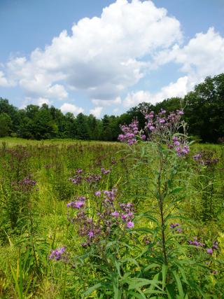
Preserve & Trail Information: 2.03 miles, Easy. This property consists of a combination of open fields and woodlands at the edge of the Sourland Mountains. The trail runs parallel to the Stony Brook and begins in a native meadow, defined by hedgerows. In the spring, vernal pools support tadpoles. The trail continues into the forest and loops around back to the meadow. Along the way you’ll find groves of red cedars, a remnant patch of old growth forest with one of the largest White Oaks around, and a maze of early 19th century stone walls.
Click here for a stewardship profile of the Cedar Ridge Preserve: http://drgreenway.org/Documents/STEWARDSHIP-PROFILE-Cedar-Ridge.pdf
History: D&R Greenway Land Trust began preserving land in this region in 1991, when the Fullam Family donated a conservation easement on the Cedar Ridge property. In 2002, the Fullams deeded the land to D&R Greenway.
Location: Van Dyke Road, Hopewell, NJ 08525
Directions: From Route 518 coming from Hopewell, turn right onto Van Dyke Road (at the blinking traffic light). The trailhead and parking lot will be on your left at the bottom of the hill, just beyond the stream crossing.
See our website for information about a D&R Greenway staff led walk on this trail in 2012: http://drgreenway.org/walks.htm#GreenwayWalks
Location:
Comments
Connections
-
-
-
- Princeton
-
-
-
-
-
-
- United States
-
- New YorkUnited States
- Copper HarborUnited States
- CardiffUnited Kingdom
- South Korea
- BaltimoreUnited States
- RichmondUnited States
- United States
- United States
- RichmondUnited States
- Canada
- Canada
- South Africa
- VeniceUnited States
- RichmondUnited States
- Brazil
- Longboat KeyUnited States
- IthacaUnited States
- BaltimoreUnited States
- HowickSouth Africa
- Brazil
- taoyuan countyTaiwan
- SquamishCanada
Multimedia
![](https://opengreenmap.org./sites/default/files/imagecache/320max/user_upload/cedar_ridge2.jpg)
Cedar Ridge Preserve and Trail
Impacts
No impacts have been left for this site yet - be the first!