Río Silao - Puente de los Cobos
Descripción


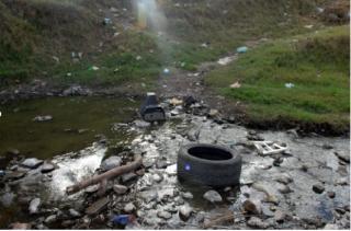
Contaminación del Río Silao - Semáforo Rojo CONAGUA 2016 - aguas arriba (saliendo de la ciudad)
(DBO 143mg/L DQO 225 mg/L SST: 48 mg/L (2016))

Location:
Javascript is required to view this map.
Comentarios
Conexiones
Compare related sites, explore the related maps, find out about volunteering, how to get here and more. Soon, you will find ways to share this map here, too.
Every site using the same primary Icon on Open Green Map is automatically linked here. You can compare different approaches and solutions on this map and others around the world.
Choose a connections category from the list on the left.
Other Sites on Map
Related Sites Worldwide
- PanevezysLithuania
- Forest HillsUnited States
- CaliColombia
- New YorkUnited States
- Taiwan
- CamdenUnited States
- CaliColombia
- Colombia
- CaliColombia
- Colombia
- CamdenUnited States
- CamdenUnited States
- United States
- Mogi MirimBrazil
- Colombia
- CamdenUnited States
- CaliColombia
- CamdenUnited States
- CamdenUnited States
- United Kingdom
- CaliColombia
- United Kingdom
- CamdenUnited States
- Brazil
- CamdenUnited States
Multimedia
Río Silao - Puente de los Cobos


Impactos
No impacts have been left for this site yet - be the first!


