Dwarsberg Point
このサイトについて


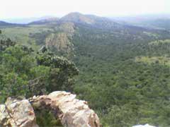
Located on the northern hiking route between Deelfontein and Thwane Camps in the Vredefort Dome area, Dwarsberg is the highest point in the Free State Dome. It also boasts the largest stand of Protea Caffra (sugarbush) in the Free State Province. This route and the Dwarsberg point offer the best views of the impact structure in the Dome.

Location:
Javascript is required to view this map.
コメント
コネクション
ここでは、関連したサイトと比較、地図の探索、ボランティアについてやこのサイトへの行きかたなどがわかります。
このグリーンサイトと同じ第一アイコンを指定しているサイトは自動的にここに表示されます。ここに表示されているほかのサイトを見て比較してみよう。
Choose a connections category from the list on the left.
この地図にある関連サイト
世界中の関連サイト
- Lebanon
-
- United States
- EurekaUnited States
- Yarmouth CountyCanada
-
-
-
- Pereiraコロンビア
- Saint Lucia
-
-
-
-
- United States
- United States
-
-
-
-
- スイス
-
-
-
-
マルチメディア
Dwarsberg Point


インパクト
まだ誰からもインパクトは報告されていません!一番目になりませんか?


