Merkle Wildlife Sanctuary and Visitor's Center
![Wildlife Habitat: Native environment for animals and the plants that sustain them. Can represent native natural environments, or protected areas such as park reserves where larger animals and other wildlife can be found. Wildlife Habitat](https://www.opengreenmap.org/sites/default/files/taxonomy_image/category_pictures_83.gif)
![Park/Recreation Area: Green space that offers a place to relax and play outdoors. May include sports fields, picnicking, running paths, canoe rental, or workout/play equipment, along with diverse vegetation and a pond, creek or other water feature. Park/Recreation Area](https://www.opengreenmap.org/sites/default/files/taxonomy_image/category_pictures_94.gif)
![Public Forest/Natural Area: Natural Reserve, National Parks, Regional Parks, other parks and public forests, even private land that has been set aside for conservation. Balance your emphasis of forests with parklands to discourage the over-use of natural areas. Public Forest/Natural Area](https://www.opengreenmap.org/sites/default/files/taxonomy_image/category_pictures_73.gif)
![Water Feature: Display or drinking fountain, beautiful waterfall or natural pond. May simply celebrate water or offer a refreshing drink in an ecologically sound way. Water Feature](https://www.opengreenmap.org/sites/default/files/taxonomy_image/category_pictures_63.gif)
![Protected/Cultivated Habitat: Ecosystem development includes wildlife corridors in urban and rural areas, resources for turning your home’s yard back into a prairie or other indigenous landscape to encouraging native animals to flourish. Protected/Cultivated Habitat](https://www.opengreenmap.org/sites/default/files/taxonomy_image/category_pictures_88.gif)
![Special Site: Place that is ecologically or culturally important to the community. It may include contributors to the map such as schools that helped make a children’s Green Map. Special Site](https://www.opengreenmap.org/sites/default/files/taxonomy_image/special_site.gif)
![Migration Zone: Good place to watch flocks of birds overhead. May indicate prevailing direction of birds' or other species' seasonal migrations. Migration Zone](https://www.opengreenmap.org/sites/default/files/taxonomy_image/category_pictures_93.gif)
Overview
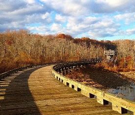
The Merkle Wildlife Sanctuary and Visitor's center is a 1,670 acre wild refuge area in Prince George's County, Maryland. It is home to the largest concentration of Canada Geese on the western shore of the Chesapeake Bay and they can be seen migrating between October and January. Merkle Wildlife Sanctuary has four trails, both flat and hilly, open to hikers. There is a 4.3 mile critical driving tour that allows visitors to see the nay watershed. The visitor's center open on weekends is where you can find interactive resources for kids and families to discover what the wildlife sanctuary is all about. Merkle also has areas for fishing, bird watching, and picnicking.
Location:
Comments
Connections
- Laurel
- Upper Marlboro
-
- Estados Unidos
-
- Reino Unido
- Reino Unido
- CardiffReino Unido
- ChasselEstados Unidos
- South Korea
- Estados Unidos
- Brazil
-
- Switzerland
- JacksonvilleEstados Unidos
- SarasotaEstados Unidos
- South Korea
- South Korea
- SavageEstados Unidos
- JacksonvilleEstados Unidos
- Estados Unidos
- Lebanon
- The Bronx, NYEstados Unidos
- Estados Unidos
- Providence
- Estados Unidos
- Sur Africa
Multimedia
![](https://opengreenmap.org./sites/default/files/imagecache/320max/user_upload/merkle_cadtbridge.jpg)
Merkle Wildlife Sanctuary and Visitor's Center
Impacts
No impacts have been left for this site yet - be the first!