Pat Sin Leng Country Park
![Public Forest/Natural Area: Natural Reserve, National Parks, Regional Parks, other parks and public forests, even private land that has been set aside for conservation. Balance your emphasis of forests with parklands to discourage the over-use of natural areas. Public Forest/Natural Area](https://www.opengreenmap.org/sites/default/files/taxonomy_image/category_pictures_73.gif)
![Wildlife Habitat: Native environment for animals and the plants that sustain them. Can represent native natural environments, or protected areas such as park reserves where larger animals and other wildlife can be found. Wildlife Habitat](https://www.opengreenmap.org/sites/default/files/taxonomy_image/category_pictures_83.gif)
![Native Forests/Plants: Flora that is indigenous in the region, sometimes called old growth, heirloom or indigenous species. Native species requires less water and care than exotic imports, and usually attract more birds, bees and butterflies, and help the cycle of life stay in balance. May include a master gardener, permaculturalist or horticulturalist or information center. Native Forests/Plants](https://www.opengreenmap.org/sites/default/files/taxonomy_image/category_pictures_75.gif)
![Eco-Tour/Nature Walk: Marks the beginning of a hiking trail, guided tour starting point or an interesting walk. Maps, signage and information may be found here. Eco-Tour/Nature Walk](https://www.opengreenmap.org/sites/default/files/taxonomy_image/category_pictures_97.gif)
![Natural Corridor/Greenway: Often follows along a river or streambed, ravine or steep hill, disused rail bed or roadway. May indicate a wildlife corridor for land animals that is left in a natural state, with native plants to shelter them. Often have paths for running, cycling, skating, etc. Natural Corridor/Greenway](https://www.opengreenmap.org/sites/default/files/taxonomy_image/category_pictures_66.gif)
![Bird and Wildlife Watching: Place to view animals in the wild. Officially recognized or locally-known sites could be accompanied by guidelines for viewing without harm, and details on the species you might see. May include organizations or wildlife centers that help protect animals. Bird and Wildlife Watching](https://www.opengreenmap.org/sites/default/files/taxonomy_image/category_pictures_90.gif)
![Camping: Area set aside for sleeping outdoors, using tents or other camping equipment. Care is needed not to destroy the surrounding vegetation, waterways, habitat or wilderness. Camping](https://www.opengreenmap.org/sites/default/files/taxonomy_image/category_pictures_104.gif)
Overview
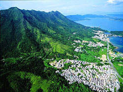
Designated in 1978, Pat Sin Leng Country Park covers 3,125 hectares of natural terrain in the Northeastern New Territories. Pat Sin Leng The "Eight Fairies" is a range of eight stately peaks, each commanding an imposing presence like the fairy in Chinese mythology. Other famous spurs within the park are Wong Leng, Ping Fung Shan, Cloudy Hill (Kau Lung Hang Shan) and Kwai Tau Leng.
These majestic uplands are set amidst emerald lakes. The picturesque Hok Tau Reservoir and Lau Shui Heung Reservoir are well known leisure destinations with a host of country park facilities. In addition to serene catchment plantations, there are lakeside barbecue areas, picnic areas and campsites. It is not a bad idea to use the campsite as a base, and explore the surrounding wild country at your leisure.
Experienced hikers can test their skills on Stage 9 and Stage 10 of the Wilson Trail, two challenging sections that traverse Pat Sin Leng Country Park. These routes travel along the ridges of Wong Leng, Lai Pek Shan and Pat Sin Leng. On fine days, the view at the top is simply arresting. For miles across, peaks roll and billow, their intense greens set against the glinting water of Plover Cove Reservoir. When the sky is clear, you can see the urban maze of Shenzhen in the distance. The conglomerate atop Pat Sin Leng is known as cap-rock, a well known rock formation in geology.
In the southern part of the park you find Sha Lo Tung the dragonfly haven, and the Ting Kok wetlands which have been declared a Site of Special Scientific Interest. In the north sits Yim Tso Ha fung shui wood. Also within the borders of Pat Sin Leng Country Park are the Chung Pui and Chung Mei barbecue and picnic areas, which are just off Bride's Pool Road.
Location:
Comments
Connections
- Airmont
- Guinea
- South Africa
- CardiffUnited Kingdom
- United Kingdom
- JerusalemIsrael
- CaliColombia
- Canada
- IthacaUnited States
- CuritibaBrazil
- United Kingdom
- South Africa
- New YorkUnited States
- United States
- GainesvilleUnited States
- United Kingdom
- CuritibaBrazil
- FlushingUnited States
- New YorkUnited States
- SwanseaUnited Kingdom
- londonCanada
- United States
- OaklandUnited States
- SwanseaUnited Kingdom
- CentervilleUnited States
Multimedia
![](https://opengreenmap.org./sites/default/files/imagecache/320max/user_upload/pat_sing_leng.jpg)
Pat Sin Leng Country Park
Impacts
No impacts have been left for this site yet - be the first!