Kalamecu grava / Kalameci Ravine
개요

Ap 240 metrus garā posmā gravas abos krastos atsedzas līdz 12 metrus augsti dolomīta atsegumi. Strauts veido vairākus ūdenskritumus un krāces.
5 kilometrus ziemeļos no Gaujienas, Markūzu upes pietekas ielejā.
Up to 12 metres high dolomite cliffs exposed at both sides of approximately 240 metres long section of ravine. Stream forms several waterfalls and rapids.
5 kilometres north from Gaujiena, valley of the tributary of Markuzas Stream.

Location:
지도를 보기 위해 Javascript가 필요합니다.
댓글
Connections
Compare related sites, explore the related maps, find out about volunteering, how to get here and more. Soon, you will find ways to share this map here, too.
Every site using the same primary Icon on Open Green Map is automatically linked here. You can compare different approaches and solutions on this map and others around the world.
Choose a connections category from the list on the left.
Other Sites on Map
Related Sites Worldwide
-
-
-
-
- IthacaUnited States
- LincolnUnited States
-
-
-
- Portugal
- Switzerland
- Lebanon
-
- Taiwan
-
- PereiraColombia
-
-
- GainesvilleUnited States
-
-
-
-
- NewarkUnited States
- United States
Multimedia

 added by
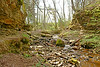
Impacts
No impacts have been left for this site yet - be the first!


