West Hyattsville Metro Station
![Public/Mass Transportation: Mass transit station or subway, bus or trolley stop. May include multi-modal transit hub served by one or more types of public transport systems. Public/Mass Transportation](https://www.opengreenmap.org/sites/default/files/taxonomy_image/category_pictures_37.gif)
![Bicycle Parking: Recommended area for secure storage or locking of bicycles with adequate lighting and bike racks at a transit station, workplace, on campus, or other area. May include attended area or valet bike parking. Bicycle Parking](https://www.opengreenmap.org/sites/default/files/taxonomy_image/category_pictures_34.gif)
![Pedestrian Friendly: Areas that favor walking over automobiles, such as pedestrian malls, plazas and traffic calmed zones that limit or restrict car traffic. Can indicate a route around an especially interesting area. Pedestrian Friendly](https://www.opengreenmap.org/sites/default/files/taxonomy_image/category_pictures_35.gif)
![Wheelchair Accessible: Accessible ramps, rails, elevators and other facilities provided for people with disabilities (useful for baby carriages and market carts, too). Wheelchair Accessible](https://www.opengreenmap.org/sites/default/files/taxonomy_image/category_pictures_36.gif)
![Light Rail/Bus Rapid Transit: Streetcar, trolley, light rail line station or stop. Also includes high-speed, express or separated lane Bus Rapid Transit systems. Light Rail/Bus Rapid Transit](https://www.opengreenmap.org/sites/default/files/taxonomy_image/category_pictures_38.gif)
![Park 'N Ride Facility: Parking lot with a convenient public transport connection for cars (or bicycles). May include electric vehicle charging spots, carpooling or car sharing resources. Park 'N Ride Facility](https://www.opengreenmap.org/sites/default/files/taxonomy_image/category_pictures_41.gif)
![Noise Pollution: Area with noisy industry, airports, quarries, heavy equipment, transportation terminals, entertainment zones etc. These places and related vibration and stress can have a powerful effect on quality of life, impacting many species. Noise Pollution](https://www.opengreenmap.org/sites/default/files/taxonomy_image/category_pictures_57.gif)
Overview
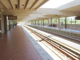
West Hyattsville Metro Station bolsters public transport for those living in the immediate area. This small city in Maryland is close to Washington D.C., but because of its constant traffic congestion, the station offers an affordable, convenient opportunity for a swift commute for many citizens of Hyattsville. The station is on the green line, a line that reaches into downtown D.C. - touching the National Mall, a multitude of high-employment centers, and many other desired points on the map of a traveler or a townie. The station hosts 50 spaces for bikes via racks, and 36 lockers for bikes as well. West Hyattsville Metro is also a station that partners with Enterprise CarShare: a service that allows temporary rental of cars. The area surrounding the station also allows for parking by those who drive to the station. Daily and monthly fees are available. All of these services provide amenities for those who wish to use public transportation to commute to work instead of using private transportation, which contributes to a mass of carbon emissions into our atmosphere.
Location:
Comments
Connections
- BothellUnited States
- NatalBrazil
-
- Brazil
- United States
-
- GenèveSwitzerland
- Staten IslandUnited States
- YogyakartaIndonesia
- United States
- United Kingdom
- ParmaUnited States
- United States
- United States
- Canada
- Brazil
- Canada
- Oakland
- Brazil
- Plan-les-OuatesSwitzerland
- New YorkUnited States
- MontclairUnited States
- Canada
- Philadelphia
- Grand-Lancy, CarougeSwitzerland
Multimedia
![](https://opengreenmap.org./sites/default/files/imagecache/320max/user_upload/westhyattsville_6.jpg)
West Hyattsville Metro Station
Impacts
No impacts have been left for this site yet - be the first!