Glacial River Bike Trail
개요


The Glacial River Bike Trail was developed through the "Rails to Trails" program, winding through Fort Atkinson south to the Rock County Border. This spectacular trail features an archway, bronze sculptures, rest areas and fountains.
Stats
Distance: 8.6 miles one-way
Surface type: 5.3 miles asphalt paved, 3.6 miles crushed limestone
Trailhead locations: At the end of Farmco Lane off Business Hwy 26 (Janesville Ave) 1.6 miles south of the Business Hwy 26 & Hwy 12 intersection in Fort Atkinson.
The trail can also be accessed from city streets with on-street parking at Jones Park in Fort Atkinson or downtown at the Municipal Building parking lot north of the Rock River at Hwy 12 (N Main St) and N Water St.
The Glacial River Trail is a multi-modal trail. It is located on a former railroad bed along Highway 26 southwest of Fort Atkinson. Parking is located at Farmco Lane and the trail stretches to the Rock County line. About one third of the trail is paved and parking is available at Farmco Lane and County Line Road. Bikers, joggers, walkers, dog walkers and in-line skaters make heavy use of the trail and it is plowed in the winter. The trail passes by farmsteads, prairie flowers, wetlands, woods, over streams, and through an award winning covered bridge. There is a connecting trail in the City of Fort Atkinson.

댓글
Connections
- Sammamish River WatershedUnited States
- United States
- bothellUnited States
- FlorianópolisBrazil
- Petit-LancySwitzerland
- United States
- Taiwan
- United States
- Cluj-NapocaRomania
- United States
- GainesvilleUnited States
- Wisconsin RapidsUnited States
- United States
- Brazil
- BaltimoreUnited States
- CairnsAustralia
- New Hartford
- SquamishCanada
- Portugal
- LondonCanada
- BacauRomania
- Portugal
- FlorianópololisBrazil
- United States
- United States
Multimedia
 added by
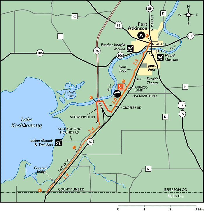
Impacts


