COMPLETED: 14th Street Initiative
Overview

14th Street extends in a north-south direction from Broad Street to the James River and Mayo Bridge in Richmond’s Downtown District. Few businesses front 14th Street. However, the corridor serves as a primary route for pedestrians and vehicles, providing access to and egress from Shockoe Bottom businesses, Richmond’s Canal Walk, the James Monroe Office Building and two Commonwealth of Virginia parking garages. The area is a gateway to the city from I-95, a center of local and state government, tourism and entertainment, bordered at the north by the Virginia Commonwealth University School of Medicine, and on the south by the environmentally sensitive James River watershed.
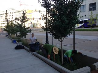
Noting the site’s barren landscape and steep slope toward the river, Capital Trees selected the 14th Street corridor as a pilot project in 2010. Working with city officials, architecture firm 3north and Waterstreet Studio, the team set out to transform this heavily travelled concrete canyon.
Plans were developed for two phases of streetscape enhancements, calling for removal of tons of concrete and dead and dying street trees, expanded tree wells, replacement with trees suitable for the adverse urban environment, pedestrian lighting, improved sidewalks, educational signage and low-impact development (LID) storm water facilities intended to reduce storm water runoff and improve storm water quality.

Location:
Comments
Connections
-
-
- Richmond
- Richmond
- Richmond
-
-
- United States
- United States
- United States
- WenonahUnited States
- SarasotaUnited States
- CraikCanada
- SarasotaUnited States
- OspreyUnited States
- United States
- VeniceUnited States
- VeniceUnited States
- SarasotaUnited States
- WestamptonUnited States
- EnglewoodUnited States
- PietermaritzburgSouth Africa
- SarasotaUnited States
- SarasotaUnited States
- CranfordUnited States
- NokomisUnited States
- SarasotaUnited States
- SarasotaUnited States
- United States
- VeniceUnited States
- SarasotaUnited States
- United States
Multimedia

COMPLETED: 14th Street Initiative

Impacts
No impacts have been left for this site yet - be the first!


