Mississippi River Floodplain
Visão geral


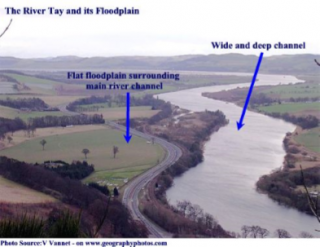
This floodplain is located just north of DuPont Reservation Conservation Area. Floodplains are located near rivers, and easily flood when the rivers rise to accommodate more water. This is possible because floodplains are often very flat, which makes it easy for the river to flow into them. When the floodplains flood, many rich nutrients are left behind, meaning floodplains provide some of the best naturally available farmlands. Floodplains also support a very diverse set of species, both when flooded and when dry. When dry, different species of birds can feed and use the area to help them migrate, and when wet, aquatic wildlife thrives, helping to create habitats and the reproduction of fish. This floodplain is characterized by few trees, unlike the surrounding areas, and looks to be eroded after years of flooding. This is not necessarily uncommon, but floodplains can definitely have different species of plants and trees growing, even while flooded. When flooded, this floodplain would undoubtedly support a wide variety of species until the water level drops. These floodplains are vital to the river, especially when they flood. They are able to reduce the pressure on other man-made flood preventing structures, such as levees, as they provide a great space for the river to expand when flooding. This floodplain is a great representation of a floodplain, because it is easy to recognize, and is like many other floodplains along the Mississippi River; Flat, directly next to the river, and easy to identify. Below are some resources I used to research floodplains.
https://prairierivers.org/priorities/wetlands-floodplains/
https://www.nationalgeographic.org/encyclopedia/flood-plain/

Location:
Comentários
Connections
- GainesvilleUnited States
- GainesvilleUnited States
- NewarkUnited States
-
- United States
-
-
- GainesvilleUnited States
-
-
-
- OaklandUnited States
-
- PereiraColombia
-
- Switzerland
-
- United Kingdom
-
-
- IthacaUnited States
- MontclairUnited States
-
-
- United Kingdom
Multimedia

Mississippi River Floodplain

Impacts
No impacts have been left for this site yet - be the first!


