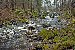
Narūžas Velna grāvis / Naruza Devil's Ditch
Visão geral
Vieta, kur Naružas upīte šķērso ap 30 metrus platu laukakmeņu krāvumu veidojot neprastas krāces.
Naružas augštecē, Velna grāvī, ziemeļaustrumos no Sknidēniem.
Location where Naruza River crosses approximately 30 metres wide pile of boulders, forming unusual rapids.
Upper reaches of Naruza, in Velna gravis, northeast from Sknideni.
Location:
Javascript is required to view this map.
Comentários
Connections
Compare related sites, explore the related maps, find out about volunteering, how to get here and more. Soon, you will find ways to share this map here, too.
Every site using the same primary Icon on Open Green Map is automatically linked here. You can compare different approaches and solutions on this map and others around the world.
Choose a connections category from the list on the left.
Other Sites on Map
Related Sites Worldwide
- CharlestonUnited States
- United States
- United States
- Scotch PlainsUnited States
- SwedesboroUnited States
- IthacaUnited States
- Canada
- Taiwan
- RichmondUnited States
- Taiwan
- AlloaUnited Kingdom
- Taiwan
- Parsippany-Troy HillsUnited States
- WheelingUnited States
- Ras Al KhaimahUnited Arab Emirates
- BaltimoreUnited States
-
- VoorheesUnited States
- LawnsideUnited States
- BlackwoodUnited States
- United Kingdom
- BaltimoreUnited States
- CaliColombia
- South Africa
- Surf CityUnited States
Impacts
No impacts have been left for this site yet - be the first!


 added by


