St Michaels Farm Preserve and Trail Network
![Ecoturismo/Caminhada pela Natureza: Marca o início de uma trilha de caminhada ou de um tour guiado. Mapas, sinalização e informação podem ser obtidos aqui. Ecoturismo/Caminhada pela Natureza](https://www.opengreenmap.org/sites/default/files/taxonomy_image/category_pictures_97.gif)
![Feira de Produtores/Feira Local: Local de venda de produtos frescos produzidos localmente. Podem ser alimentos orgânicos ou tradicionais, flores, artesanato, pão, vinho, lã e, até mesmo, livros de culinária regional. Apoia pequenas propriedades familiares, economias locais e uma área rural mais verde. Feira de Produtores/Feira Local](https://www.opengreenmap.org/sites/default/files/taxonomy_image/category_pictures_0.gif)
![Habitat de Espécies Selvagens: Ambiente nativo para animais e para as plantas que os sustentam. Pode representar ambientes nativos naturais ou áreas de proteção como reservas naturais nas quais grandes animais e outras formas de vida selvagem podem ser encontrados. Habitat de Espécies Selvagens](https://www.opengreenmap.org/sites/default/files/taxonomy_image/category_pictures_83.gif)
![Florestas/Plantas Nativas: Flora que seja natural da região. As espécies nativas requerem menos água e cuidados que as exóticas (importadas) e, normalmente, atraem mais pássaros, abelhas, borboletas e outros polinizadores, ajudando a manter o ciclo da vida em equilíbrio. Pode incluir jardins ou hortos florestais, áreas de permacultura ou agricultura orgânica e centros de informação. Florestas/Plantas Nativas](https://www.opengreenmap.org/sites/default/files/taxonomy_image/category_pictures_75.gif)
![Local de Observação de Insetos: Boa área para observar insetos enquanto eles voam ou rastejam em seu meio natural. Local de Observação de Insetos](https://www.opengreenmap.org/sites/default/files/taxonomy_image/category_pictures_89.gif)
![Local de Observação de Pássaros e Outras Formas de Vida Selvagem: Lugar para observar animais em seu ambiente natural. As indicações dos locais oficialmente reconhecidos ou conhecidos pelos moradores locais podem ser acompanhadas por orientações para a observação sem causar danos e de detalhes sobre as espécies que podem ser observadas. Pode incluir organizações e centros dedicados à proteção da vida animal. Local de Observação de Pássaros e Outras Formas de Vida Selvagem](https://www.opengreenmap.org/sites/default/files/taxonomy_image/category_pictures_90.gif)
![Vista Panorâmica: Lugares privilegiados para observar tudo o que torna o ambiente da comunidade especial. Vista Panorâmica](https://www.opengreenmap.org/sites/default/files/taxonomy_image/category_pictures_105.gif)
Visão geral
St Michaels Farm Preserve and Trail Network
Size: 340 acres
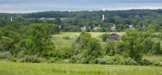
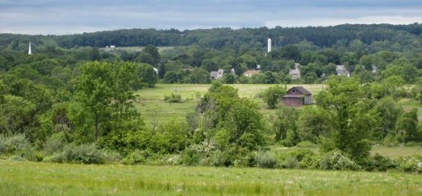
Preserve & Trail Information: 5.8 miles, when completed. Easy. From Aunt Molly Rd, walk uphill to the Charles Evans Overlook, where you’ll get a long view down the valley towards Hopewell. The trail continues on farm roads along the perimeter of agricultural fields and enters the woods at the top of the property. The trail is lined with hedgerows, where D&R will plant native fruit-bearing shrubs and trees to provide food for wildlife (and people too!). An ornithologist has identified over 100 bird species on the property. When completed, the trail network will be 5.8 miles. St. Michaels is also accessible from Carter Rd, just south of Hopewell.
Click here for a trail map: http://www.drgreenway.org/Documents/StMichael.pdf
History: The St. Michaels property was preserved in 2010 through a partnership between D&R Greenway Land Trust, the NJ State Agricultural Development Committee, Mercer County, Hopewell Borough and Township, and the NJ Department of Environmental Protection Green Acres Program. From 1896 to 1973, the property was the home of St. Michaels Orphanage and Industrial School, operated by the Catholic Diocese of Trenton. A lease has been signed for a local farmer to graze cattle, sheep and chickens on the open fields that are to the south of Bedens Brook and for the present, much of the open land to the north of the Brook will be used for hayfields.
Location: Between Carter and Aunt Molly Rd, Hopewell, NJ 08525
Directions: There are two access points to St. Michaels. From Route 518, turn onto Aunt Molly Rd. The preserve entrance will be on your right and street parking is available.
Or, take Carter Rd (Hopewell-Princeton Rd) towards Hopewell. Look for a gravel parking lot on your right before you reach Hopewell.
Location:
Comentários
Connections
-
-
-
-
-
-
-
-
- Princeton
-
- Hong KongHong Kong S.A.R., China
- VeniceUnited States
-
-
- United States
- United States
- United States
- DahlonegaUnited States
- HawthorneUnited States
- Lebanon
- Lebanon
- DubuqueUnited States
- South Africa
- Canada
- IthacaUnited States
- RichmondUnited States
- Port ElginCanada
- Cape TownSouth Africa
- Lebanon
- BronxUnited States
- GainesvilleUnited States
- Canada
- CockeysvilleUnited States
- RichfordUnited States
- Canada
Multimedia
![](https://opengreenmap.org./pt-br/sites/default/files/imagecache/320max/user_upload/st_michaels1.jpg)
St Michaels Farm Preserve and Trail Network
Impacts
No impacts have been left for this site yet - be the first!