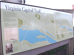
Virginia Capital Trail
Visão geral
The Virginia Capital Trail is a joint project of VDOT and the Virginia Capital Trail Foundation. Construction began in 2003 and by March 2010 there were 15 miles of trail completed. The Richmond Riverfront section can be accessed at Great Shiplock Park at the intersection of Pear St. and Dock St and connects with Richmond's Canal Walk. The first half-mile phase of this section has been completed and is open to the public year round. Upon completion, the Virginia Capital Trail will run over 55 miles along the James River and VA route 5, including several trail spurs, connecting the cities of Richmond and Williamsburg, VA.
Location:
Javascript is required to view this map.
Comentários
Connections
Compare related sites, explore the related maps, find out about volunteering, how to get here and more. Soon, you will find ways to share this map here, too.
Every site using the same primary Icon on Open Green Map is automatically linked here. You can compare different approaches and solutions on this map and others around the world.
Choose a connections category from the list on the left.
Other Sites on Map
Related Sites Worldwide
- United States
- Canada
- Taiwan
- Australia
- United States
- United Kingdom
- Switzerland
- United States
- United States
- Taiwan
- YogyakartaIndonesia
- CuritibaBrazil
- Port Talbot
- Brazil
- Atlantic HighlandsUnited States
- MadisonUnited States
- Switzerland
- Sammamish River WatershedUnited States
- Sammamish River WatershedUnited States
- FlorianópolisBrazil
- CuritibaBrazil
- United States
- FlorianópolisBrazil
- GainesvilleUnited States
- NewarkUnited States
Impacts
No impacts have been left for this site yet - be the first!


 added by


