HSBC TreeTop Walk
![Corredor Natural: Freqüentemente segue o curso de um rio ou leito de rio, ravina ou colina, antigo trilho ferroviário ou rodovia. Pode indicar um corredor de vida selvagem para animais terrestres e que é deixado em seu estado natural, com vegetação nativa que serve como abrigo para a fauna. Muitas vezes possui trilhas para caminhada, ciclismo, etc. Corredor Natural](https://www.opengreenmap.org/sites/default/files/taxonomy_image/category_pictures_66.gif)
![Floresta/Área Natural Pública: Reserva Natural, Parques Nacionais e Municipais, outros parques e florestas públicas, e, até mesmo áreas privadas que tenham sido preservadas para a conservação. Equilibre sua ênfase em matas naturais com áreas de parque para desencorajar a superutilização de áreas naturais. Floresta/Área Natural Pública](https://www.opengreenmap.org/sites/default/files/taxonomy_image/category_pictures_73.gif)
![Habitat Importante: Ecossistema de vida selvagem ou área de acasalamento e reprodução que podem ser raros ou especialmente belos e ricos. Habitat Importante](https://www.opengreenmap.org/sites/default/files/taxonomy_image/category_pictures_82.gif)
![Árvore Especial: Marca uma árvore que seja culturalmente ou ecologicamente importante na comunidade. Pode ser uma árvore antiga, virgem (nunca cortada pelo homem), sagrada, medicinal ou nativa. Pode estar dentro de alguma construção ou ser de uma espécie ameaçada. Árvore Especial](https://www.opengreenmap.org/sites/default/files/taxonomy_image/category_pictures_74.gif)
![Florestas/Plantas Nativas: Flora que seja natural da região. As espécies nativas requerem menos água e cuidados que as exóticas (importadas) e, normalmente, atraem mais pássaros, abelhas, borboletas e outros polinizadores, ajudando a manter o ciclo da vida em equilíbrio. Pode incluir jardins ou hortos florestais, áreas de permacultura ou agricultura orgânica e centros de informação. Florestas/Plantas Nativas](https://www.opengreenmap.org/sites/default/files/taxonomy_image/category_pictures_75.gif)
![Feição/Característica Geológica: Local ou área onde formas geológicas pouco usuais ou típicas estão aparentes na paisagem. Podem ser camadas ou afloramentos de rocha, sedimentos glaciais ou uma vista de uma fenda. Inclui espaços abertos significantes, pradarias [cerrados], desertos, uma montanha importante ou outro marco de referência natural importante. Feição/Característica Geológica](https://www.opengreenmap.org/sites/default/files/taxonomy_image/category_pictures_67.gif)
![Local de Observação de Pássaros e Outras Formas de Vida Selvagem: Lugar para observar animais em seu ambiente natural. As indicações dos locais oficialmente reconhecidos ou conhecidos pelos moradores locais podem ser acompanhadas por orientações para a observação sem causar danos e de detalhes sobre as espécies que podem ser observadas. Pode incluir organizações e centros dedicados à proteção da vida animal. Local de Observação de Pássaros e Outras Formas de Vida Selvagem](https://www.opengreenmap.org/sites/default/files/taxonomy_image/category_pictures_90.gif)
Visão geral
HSBC TreeTop Walk
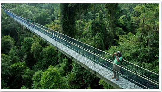
The nature reserve contains a 250-metre suspension bridge. The HSBC TreeTop Walk opened to public on 5 November 2004. It connects the two highest points in MacRitchie - Bukit Pierce and Bukit Kalang. At the highest point, the bridge hangs 25 metres from the forest floor. The difficulty level of the trail ranges from moderate to difficult. The suspension bridge serves an important role in forest canopy research, giving researchers access to areas well off the ground. To preserve tranquility of the environment and for safety reasons, the number of people allowed on the walkway is capped at 30. Visitors will only be able to travel along the narrow walkway in one direction, by entering from the Bukit Pierce entrance and exiting through the Petaling Trail. Rangers are deployed along the 10.3-kilometre trail to ensure safety.
The TreeTop Walk (TTW) is the highlight of several long hiking routes in MacRitchie that brings you through different stages of mature secondary forest. The first of its kind in Singapore and in the region, this free-standing suspension bridge connects the two highest points (Bukit Peirce and Bukit Kalang) in MacRitchie and offers a bird's eye view of the community of plants and animals that live in the forest canopy. The total length of the walkway is about 250m and its height from the forest floor varies, with the highest point at 25m.
Besides providing another avenue for nature recreation for Singaporeans, the TTW also play an important role in forest canopy research, an area many researchers were not able to get into because of lack of access. This bridge will help to facilitate surveys and plant identification work and further our understanding of how forest ecosystems work.
Location:
Comentários
Connections
n/a
- Cape Town
- IthacaUnited States
- Hong Kong S.A.R., China
- PereiraColombia
- Hong Kong S.A.R., China
- Romania
- United States
- United States
- Canada
- RaleighUnited States
- United States
- San AntonioUnited States
- FlorianopolisBrazil
- United States
- United Kingdom
- Canada
- PrestonUnited Kingdom
- IthacaUnited States
- Switzerland
- United Kingdom
- Taiwan
- United States
- IthacaUnited States
- Hong Kong S.A.R., China
-
Multimedia
![](https://opengreenmap.org./pt-br/sites/default/files/imagecache/320max/user_upload/hsbc_treetop_walk.png)
HSBC TreeTop Walk
Impacts
No impacts have been left for this site yet - be the first!