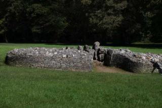
Parc le Breos Burial Chamber
Visão geral


Neolithic tomb belonging to the so-called Severn–Cotswold group. Run by CADW. www.cadw.wales.gov.uk.

Location:
Javascript is required to view this map.
Comentários
Connections
Compare related sites, explore the related maps, find out about volunteering, how to get here and more. Soon, you will find ways to share this map here, too.
Every site using the same primary Icon on Open Green Map is automatically linked here. You can compare different approaches and solutions on this map and others around the world.
Choose a connections category from the list on the left.
Other Sites on Map
- Curitiba
-
- Atlantic Highlands
-
- São José
-
- Curitiba
-
- Long Valley
- Fife
Related Sites Worldwide
- United States
- LindsayCanada
- FifeUnited Kingdom
- Atlantic HighlandsUnited States
- United States
- United States
- United States
-
- United States
- United States
- United States
- RichmondUnited States
- San FranciscoUnited States
- CampbellfordCanada
- Brazil
- United States
- Staten Island, NY
- SealevelUnited States
- New YorkUnited States
- GenèveSwitzerland
- AtlanticUnited States
- HillsboroughUnited States
- PeterboroughCanada
- Cesky KrumlovCzech Republic
- New YorkUnited States
Multimedia
Parc le Breos Burial Chamber


Impacts
No impacts have been left for this site yet - be the first!


