Salt River Tributary
Rezumat


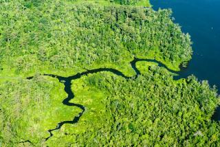
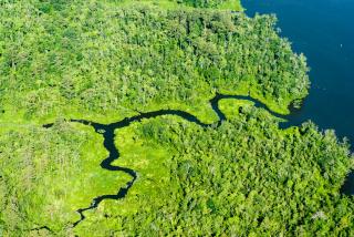
Just north of Louisiana, Missouri, Salt River flows into the Mississippi. This is the perfect example of a tributary, which is defined as a stream or river which flows into a larger stream, river, or body of water. Tributaries can be relatively small compared to other rivers, or massive. For instance, the Missouri River is a tributary of the Mississippi River (the largest one, in fact!), just as Salt River is, but the Missouri River is much longer, and carries much more water than Salt River. The requirements needed to be identified as a tributary are very minimal, and essentially only consist of flowing into a larger stream or river. Salt River is one of hundreds of tributaries of the Mississippi River, which flows for more than 2,000 miles. Salt River travels for around sixty three miles before it empties into the Mississippi. The point at which the rivers meet is called the confluence, and in this instance, because Salt River empties into the Mississippi River, the Mississippi River is considered the mainstream. I decided to map the tributary at the confluence, but you can follow Salt River as it twists and turns through Missouri. Tributaries provide mainstreams with a vast majority of the watershed which comprises the river. I can say that I have had plenty of experience with tributaries, and I would bet many people have too. The Meramec River is actually a tributary of the Mississippi River, with a confluence near Oakville, Missouri. I have been on several float trips down the Meramec River over the years, but I never knew it was a tributary! I think it’s really interesting to consider how different tributaries can be, even though they can all be categorized under the same title. A small stream a few miles long is just as much a tributary as the Missouri River, as long as it flows into a larger body of water. There’s a lot of interesting articles and information about Salt River and tributaries in general, below is the links to some of the information I read (National Geographic and the Missouri Department of Conservation)
https://mdc.mo.gov/your-property/greener-communities/missouri-watershed-... https://www.nationalgeographic.org/encyclopedia/tributary/ent/salt-river

Location:
Comentarii
Conexiuni
- SwedesboroUnited States
- NewarkUnited States
- ByramUnited States
- PereiraColombia
- United States
- FranklinUnited States
- SalemUnited States
- United Kingdom
- CamdenUnited States
- United Kingdom
- WheelingUnited States
- New BrunswickUnited States
- ClaytonUnited States
- FreeholdUnited States
- HiltonSouth Africa
- United States
- United States
- MillvilleUnited States
- Parma HeightsUnited States
- United States
- United Kingdom
-
- BaltimoreUnited States
-
- South Africa
Multimedia
Salt River Tributary

Impact
No impacts have been left for this site yet - be the first!


