COMPLETED: 21st Street Entrance to the James River Park
![Pedestrian Friendly: Areas that favor walking over automobiles, such as pedestrian malls, plazas and traffic calmed zones that limit or restrict car traffic. Can indicate a route around an especially interesting area. Pedestrian Friendly](https://www.opengreenmap.org/sites/default/files/taxonomy_image/category_pictures_35.gif)
![Public Forest/Natural Area: Natural Reserve, National Parks, Regional Parks, other parks and public forests, even private land that has been set aside for conservation. Balance your emphasis of forests with parklands to discourage the over-use of natural areas. Public Forest/Natural Area](https://www.opengreenmap.org/sites/default/files/taxonomy_image/category_pictures_73.gif)
![Bicycle Path : Designated and recommended bicycle paths or lanes. Bicycle Path](https://www.opengreenmap.org/sites/default/files/taxonomy_image/category_pictures_169.gif)
![Native Forests/Plants: Flora that is indigenous in the region, sometimes called old growth, heirloom or indigenous species. Native species requires less water and care than exotic imports, and usually attract more birds, bees and butterflies, and help the cycle of life stay in balance. May include a master gardener, permaculturalist or horticulturalist or information center. Native Forests/Plants](https://www.opengreenmap.org/sites/default/files/taxonomy_image/category_pictures_75.gif)
![Bicycle Parking: Recommended area for secure storage or locking of bicycles with adequate lighting and bike racks at a transit station, workplace, on campus, or other area. May include attended area or valet bike parking. Bicycle Parking](https://www.opengreenmap.org/sites/default/files/taxonomy_image/category_pictures_34.gif)
![Water Recycling: Uses plants, aquatic animals, layered soils, movement, (constructed) wetlands and or/ swales to aerate, filter and purify water, without adding chemicals. Systems that slow the drainage in the built environment, grey water, rainwater gardens, rain barrels and other types of high and low technology water recycling systems that reduce consumption can be included. Water Recycling](https://www.opengreenmap.org/sites/default/files/taxonomy_image/category_pictures_20.gif)
Overview
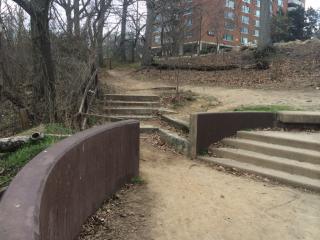
Improvements to the area leading to the 21st Street tower alongside Riverside Drive include the removal of the defunct shelter next to the street, defined stepping-stone pathways, a bike repair station, and bike parking. In addition, the site plan includes rain gardens filled with native plant species to reduce maintenance while beautifying the area.
The $90,000 worth of improvements was funded by a grant from Altria tied to the 2015 UCI Road World Championships and provided to the city by the James River Association.
In addition to the renovations made possible through Altria and the James River Association, the Public Works Traffic Engineering Department will improve pedestrian access with the installation of curb cuts, cross walks, and pedestrian crossing signs.
Location:
Comments
Connections
- Estados Unidos
- Estados Unidos
- BaltimoreEstados Unidos
- Switzerland
- Saint LouisEstados Unidos
- Estados Unidos
- Greece
- CaliColombia
- Carlisle
- Atlanta, Ga
- Atlanta, Ga
- Estados Unidos
- BaltimoreEstados Unidos
- CaliColombia
- Estados Unidos
- ClevelandEstados Unidos
- Byron BayAustralia
- Reino Unido
- Estados Unidos
- San AntonioEstados Unidos
- Estados Unidos
- 10009 NY
- New York City
- DosquebradasColombia
- New YorkEstados Unidos
Multimedia
![](https://opengreenmap.org./sites/default/files/imagecache/320max/user_upload/21st_street.jpg)
COMPLETED: 21st Street Entrance to the James River Park
Impacts
No impacts have been left for this site yet - be the first!