River Bank Erosion
Översikt


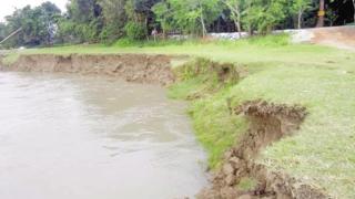
Erosion in this example ties directly with the formation of a meandering curve. The outermost bank, or “cut bank” experiences erosion when the river carries mud and debris which erode the bank of the river. This is a process which can take thousands of years, depending on the river and how much of the bank has eroded. This form of erosion can be further classified as lateral erosion, because of the river expanding laterally, rather than vertically, which makes the river deeper. This type of erosion can also be due to valley erosion, which is a fancy way of saying the river water cuts into the bank over time, creating a larger valley. There are many signs of erosion up and down the Mississippi river, as it has been slowly eroding for thousands of years. These signs of erosion are typically characterized by “dips” in the river banks. This is how I identified the erosion just south of “Blackbird Island” because of how the bank has an elongated “U” shape before some of the dirt and debris is collected after the erosion site. In many cases where the river twists and turns, there will be erosion to a certain degree, just because of how powerful the river is with all of the dirt and debris it carries. Ultimately, erosion causes the river to constantly change, because a change in one aspect of the river can alter how the river flows both upstream and downstream from the erosion. Erosion is a naturally occurring aspect of many rivers and bodies of water across the world, and there are many different instances of erosion on the Mississippi! Below are a few links to erosion related articles I read while identifying erosion, some of them contain pretty interesting information!
https://www.americangeosciences.org/education/k5geosource/content/rocks/...
https://www.nationalgeographic.org/encyclopedia/erosion/

Location:
Kommentarer
Kopplingar
-
-
-
-
-
-
-
-
-
-
- IthacaUnited States
-
-
-
-
- Portugal
- Portugal
-
- IthacaUnited States
- GainesvilleUnited States
-
- ChattanoogaUnited States
- SharjahUnited Arab Emirates
-
-
Multimedia

River Bank Erosion

Påverkan
Ingen påverkan har registrerats för denna plats än - du kan bli först!


