Tai Mo Shan Country Park
![Public Forest/Natural Area: Natural Reserve, National Parks, Regional Parks, other parks and public forests, even private land that has been set aside for conservation. Balance your emphasis of forests with parklands to discourage the over-use of natural areas. Public Forest/Natural Area](https://www.opengreenmap.org/sites/default/files/taxonomy_image/category_pictures_73.gif)
![Wildlife Habitat: Native environment for animals and the plants that sustain them. Can represent native natural environments, or protected areas such as park reserves where larger animals and other wildlife can be found. Wildlife Habitat](https://www.opengreenmap.org/sites/default/files/taxonomy_image/category_pictures_83.gif)
![Native Forests/Plants: Flora that is indigenous in the region, sometimes called old growth, heirloom or indigenous species. Native species requires less water and care than exotic imports, and usually attract more birds, bees and butterflies, and help the cycle of life stay in balance. May include a master gardener, permaculturalist or horticulturalist or information center. Native Forests/Plants](https://www.opengreenmap.org/sites/default/files/taxonomy_image/category_pictures_75.gif)
![Eco-Tour/Nature Walk: Marks the beginning of a hiking trail, guided tour starting point or an interesting walk. Maps, signage and information may be found here. Eco-Tour/Nature Walk](https://www.opengreenmap.org/sites/default/files/taxonomy_image/category_pictures_97.gif)
![Natural Corridor/Greenway: Often follows along a river or streambed, ravine or steep hill, disused rail bed or roadway. May indicate a wildlife corridor for land animals that is left in a natural state, with native plants to shelter them. Often have paths for running, cycling, skating, etc. Natural Corridor/Greenway](https://www.opengreenmap.org/sites/default/files/taxonomy_image/category_pictures_66.gif)
![Bird and Wildlife Watching: Place to view animals in the wild. Officially recognized or locally-known sites could be accompanied by guidelines for viewing without harm, and details on the species you might see. May include organizations or wildlife centers that help protect animals. Bird and Wildlife Watching](https://www.opengreenmap.org/sites/default/files/taxonomy_image/category_pictures_90.gif)
![Camping: Area set aside for sleeping outdoors, using tents or other camping equipment. Care is needed not to destroy the surrounding vegetation, waterways, habitat or wilderness. Camping](https://www.opengreenmap.org/sites/default/files/taxonomy_image/category_pictures_104.gif)
Overview
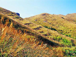
Standing 957 metres, Tai Mo Shan is Hong Kong's highest peak. Enveloping this massif is 1,440 hectares of natural territory, designated as the Tai Mo Shan Country Park. Established in 1979, the park borders Tai Po Kau Nature Reserve in the east and Shing Mun Country Park in the south. To the west is Route Twisk and Tai Lam Country Park just beyond the highway. To the north is the old valley of Lam Tsuen.The highest peak of Hong Kong is pure volcanic rock. The southern, western and southwestern valleys are characterized by heavy deposits of alluvial soil. Given the high altitude and climatic adversities, these uplands are generally infertile. As a result, most parts of Tai Mo Shan Country Park are grass slopes, with limited forests only in the foothills.
Location:
Comments
Connections
- Lebanon
- GainesvilleUnited States
- United States
- Darmstadtドイツ
- kawkabaLebanon
- Caliコロンビア
- Indonesia
- Lebanon
- IthacaUnited States
- SwanseaUnited Kingdom
- United Kingdom
-
- Uganda
- United Kingdom
- United States
- United Kingdom
- FlushingUnited States
- KloofendalSouth Africa
- LondonCanada
- Cape TownSouth Africa
- Brazil
- Cape TownSouth Africa
- South Africa
- Genèveスイス
- shanghaiChina
Multimedia
![](https://opengreenmap.org./sites/default/files/imagecache/320max/user_upload/tai_mo_shan.jpg)
Tai Mo Shan Country Park
Impacts
No impacts have been left for this site yet - be the first!