Acleja (Avoti pie Mežzīlēm) / Acleja (springs near Mezziles)
概览

Neparastu avotu grupa - ļoti dziļu, dzidru ezeriņu grupa mežā, no kuriem izplūst dzidri strauti.
Mežā starp Mežzīlēm un karjeru.
Group of unusual springs - group of very deep, lucid lakes in the forest, powerful lucid streams flowing out.
In the forest betweeb Mezziles and quarry.

Location:
Javascript is required to view this map.
评论
Connections
Compare related sites, explore the related maps, find out about volunteering, how to get here and more. Soon, you will find ways to share this map here, too.
Every site using the same primary Icon on Open Green Map is automatically linked here. You can compare different approaches and solutions on this map and others around the world.
Choose a connections category from the list on the left.
Other Sites on Map
Related Sites Worldwide
-
- 加拿大
- Timişoara罗马尼亚
- 黎巴嫩
- 巴西
- 黎巴嫩
- Petit-Lancy瑞士
- 英国
-
- 黎巴嫩
- Shokan美国
- 巴西
-
-
- 美国
-
- Genève瑞士
- Delaware County美国
- 加拿大
- Santana de Parnaíba巴西
- 黎巴嫩
- 黎巴嫩
- 希腊
- 罗马尼亚
- 瑞士
Multimedia

 added by
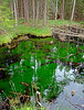
Impacts
No impacts have been left for this site yet - be the first!


